a_c
Paddler
So I seem to recall a post a while back (1 year? 3 years? These days it's all a blur) about certain campsites that would be disappearing from the BC Marine Trails website. The gist of the post was, grab a screenshot before they're gone, or something to that effect. A tenure issue, or FN related?
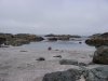
Anyway, I'm heading up that way in mid-August and I recall a campsite in the vicinity, maybe called Iron Bay or something? I'm sure there was something there, does anyone have any information on this? The site shown on the screen shot is Tongue Point West.
Also, can anyone confirm fresh water availability in the Nuchatlitz area? I know Benson Point has (had?) a small supply, but wondering what else is available, if anything.
Thanks!
")